Version Francaise How far is it? Ojai is 1h30 away from LA driving north-west. About 30 minutes...
LOS PADRES NATIONAL FOREST (Ojai)
How far is it?

Ojai is 1h30 away from LA driving north-west. About 30 minutes north of Ojai on the winding Jacinto Reyes Scenic Byway — or “up the 33”, you will find access to the Los Padres National Forest and some beautiful hikes and swimming spots.
Best outdoor activities
You’ll want to know where you’re going before you hit the road as Wi-Fi will be scarce along the way. On weekends, stop at the Wheeler Gorge Visitor Center for a parking pass or use your California Adventure Pass.
Piedra Blanca Trail & Sespe River swimming hole

You want to head towards the “Piedra Blanca Trailhead” (put that in your GPS before losing signal completely, so before leaving Ojai) parking lot.
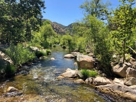
Once parked there, start taking the trail and after about 5 minutes hiking, you will see smaller paths leaving the main trail towards the left, where the river is.
Follow them and you will arrive at the swimming hole. You can stay in the shade under the cottonwood trees and put your hammock for a nap, or go jump from the big boulders and splash around!
The water is deep enough for it, yet you won’t feel any current so it feels very safe for the whole family. What a nice change from the ocean too!
Rose Valley Falls

One of the most famous hikes is Rose Valley Falls. The trail is approximately 1.6 miles round trip and is considered easy to moderate in difficulty.
The trailhead is located at the end of Rose Valley Road, where there is a small parking lot. From there, the trail follows a dirt path through a scenic canyon, shaded by oak trees and other native vegetation. Along the way, hikers will pass by a small stream and several smaller waterfalls before arriving at the main attraction – the 300-foot Rose Valley Falls. Visitors can get up close to the falls by following a short trail that leads to the base of the waterfall. Best seen during the spring months when water flows heavily.
Also, if you are looking for more easy/moderate hikes in the Los Padres National Forest, check out the list below from Alltrails.
https://www.alltrails.com/explore/us/california/ojai?b_tl_lat=34.61292614534115&b_tl_lng=-119.472672570443&b_br_lat=34.44464046601816&b_br_lng=-119.06063336870929&mobileMap=true&diff[]=easy&diff[]=moderate&length[]=0&length[]=12874.752
Ventura River Preserve

The Ventura River Preserve also offers nice and fairly easy trail options with great scenery and the Ventura River itself, another great spot to cool down or splash around.
The Preserve is a 1,600-acre natural area located in the Upper Ventura River watershed and is managed by the Ojai Valley Land Conservancy.
The preserve features over 10 miles of hiking trails that wind through a variety of habitats, including oak woodlands, riparian areas, and grasslands. The trails range from easy to moderate, and offer stunning views of the surrounding mountains and the Ventura River.
You can find all the trails here on this map, and more information on their website:
https://ovlc.org/preserves/ventura-river-rancho-el-nido/

Where to grab a drink and/or a bite?
I am not going to list all the places you can or should check out in Ojai, as we did not really spend a lot of time in town, and I am sure you will find other websites that review them all.
But we did come across a really cute place to grab a drink and a bite before leaving town: Tipple and Ramble.
This adorable wine bar has a wonderful patio, perfectly decorated, and a selection of Cheese, charcuterie, Mediterranean spreads and empanadas to accompany your drink. A perfect place to relax after a hike!


